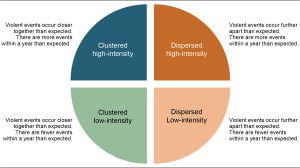
In the coming years, SWAC/OECD will develop new parameters for the Spatial Conflict Dynamics indicator (SCDi) to better map and monitor the spatial evolution of armed conflicts in North and West Africa. One of the promising new avenues of research is to combine the SCDi with socio-economic and political data such as food prices, changes in climate and local governance institutions. This combined effort would help explain how political violence and food insecurity interact in the region.
The SCDi could also incorporate other factors impacting the evolution of political violence. For example, the spatial distribution of the population or road network may influence the intensity or concentration of violent events observed in each conflict region. Another way to expand the indicator would be to map the emergence, expansion, and resolution of conflicts in the whole of the region over several decades, in order to better understand the spatial conflict life cycle.
Finally, the SCDi is a very flexible tool that can be extended to other regional contexts, beyond North and West Africa, and at different scales of analysis. Doing so can highlight how universal or localised conflict patterns and lifecycles may be. Stay tuned for future updates on the SCDi.


